Friday, May 31, 2019

Kallikratis to Argiroupoli on the E4: Day 73

An unexpectedly local breakfast, and some interesting water features were plus points today, somewhat offset by having to retrace my steps at one point due to being unable to find a viable path.
Camping in sheep country, in which many of the sheep have bells around their necks, meant that periodically in the night the noise of jangling bells came close to my tent before receding. It seems that at least some sheep graze at night and sleep under a shady tree during the day. Not a bad idea with their woolly coats.
After decamping and passing a nearby church, I walked a few kilometres down into Kallikratis. Shadows cast by the low morning sun, picked out in high contrast the detail of the trees, houses and plots of land in the village, against a backdrop of stony mountains. However it did not look like there was much in the village, so I was very pleased to find at 7:10 am in the morning an open cafe. I ordered a Greek coffee, and the proprietor (an unshaven grey haired man with a moustache) said "feta?", to which I said yes. So I had a breakfast of feta cheese, dressed with olive oil and some bread. The feta was a fresh, soft and crumbly variety and the proprietor indicated it came from the two goats in the small field opposite which he proceeded to feed. As I sat eating my cheese the occasional battered pick up passed by with a plastic churn of milk, white or brown, either from freshly milked goats or sheep as there were no cows in the area. A flock of sheep gathered on the road nearby, two of the sheep were having a head butting competition. On a gate being opened the well trained sheep went through it, I saw no shepherd or sheepdog organising them. Whether it was for milking or feeding I don't know.
Leaving Kallikratis I followed the E4 up a hill, through one of the many Cretan fences, and down the other side onto the road to Asi Gonia. To reach the bottom of a steep mountainside, the road had numerous hairpin bends. It was possible to cut off some of the loops on what the map claimed to be paths, but it was more enjoyable walking down the road admiring the view than looking down on every step to carefully place my feet among the rocks and thorn bushes on a "path". At first I thought I was going the wrong way as the sea was in the wrong place, but then I realized I was looking at the sea to the north of Crete and not the Libyan sea to the south which I had been walking beside recently.
Asi Gonia also had an open cafe where I had a Coke and cake before following my GPS route along a narrow road which became a gravel track. After a few kilometres the GPS indicated that I should head downhill to join the Asi Gonia to Argiroupoli road. I plunged through an overgrown olive grove to where I thought it should be, and after trying a few routes, and then having to climb back uphill I spotted two red stripes painted on a rock, similar to those used to mark the E4 elsewhere. First I had to negotiate the rebar fence, which seem to be everywhere in Crete. Then I had to try and find where the trail went. I found one or two of the red waymarks but not enough to work out where the path was then meant to go. My best guess was along the base of a ravine, but it was too overgrown for me to make any progress. So I was forced to return to the gravel track. To reach it I scrambled up some rocks on a steep slope, not so easy with a rucksack, and disassembled (and then reassembled) a bit of fence, not nice. Then it was a lengthy walk back to Asi Gonia before following the road route to Argiroupoli.
I marched along the road, down a steep sided valley, pretty quickly and arrived at the bottom of the hill on which Argiroupoli is built. On climbing the hill I passed coach parties of tourists. There is a natural spring which a string of restaurants have used to good effect to create water features for their customers who sit under trees, cooled by the water, eating trout. The trout seemed to be kept alive in sections of the water feature so you could be really sure of having fresh fish.
I struggled up the hill to the village, walked past some tourist type shops and a second or third century mosaic (needing a bit of a clean) to my room for tonight in Maria's rooms. Unhelpfully it does not say this on the sign outside but an older man, who spoke little English, assured me the rooms were indeed Maria's and took my passport details.
Later it was grilled vegetables and souvlaki in a restaurant with a goat statue spouting water.

I walked 29.9 kilometres including my effort to find the path with a 600 metre total ascent, if I had stuck to the road after Asi Gonia, I would have walked only 24.1 kilometres with a 390 metre total ascent.

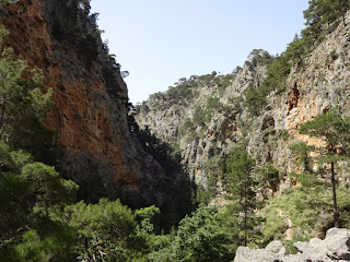
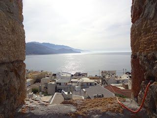
Fields around Kallikratis

The village of Asi Gonia below a stony mountain

Thursday, May 30, 2019

Hora Sfakion to Kallikratis on the E4: Day 72

Today's highlight was the walk up the Imbros Gorge, a more intimate experience than the Samaria Gorge.
At breakfast on the seafront at the Livikon hotel, I listened with admiration as the waiter switched between four languages as he addressed different customers. Suitably fed, I climbed up the road out of Hora Sfakion. Ignoring a possible detour, as it involved extra climbing in an apparently unattractive area, I followed the road, passed various cafes with adverts for taxis, to the entrance of the Imbros Gorge.
Given a loose interpretation of where the E4 goes, I had a choice of three routes, up the Imbros, Astendiano or Kallikratis Gorge. Based on guidebook recommendations I selected the Imbros, although as I later discovered it would involve a bit more climbing. Although nowhere near as popular as the Samaria Gorge, it still attracts a fair number of people who pay 2.5 euros to walk around 11 kilometres through this smaller gorge. The gorge is narrower than its bigger brother, in places you can simultaneously touch both side with your hands while the cliffs each side rise vertically above you. There is also a natural arch. With no water in the gorge today, the walking was not difficult, much of the path is flat although there were a few places with rocks and pebbles to negotiate. The cliffs each side and some trees provide a degree of shade except at each end.
At the top, in Imbros village, I had a lemon drink and ice cream at one of the tavernas before tackling the next stage of today's walk, a road section to Asfendou. Over a few kilometres the road climbed 320 metres at a steady pace. There was no shade, the vegetation was the low thorny type that covers much of Crete. The sun was out and sweat was coming into my eyes, making them sting. Once the road reached the pass, it promptly lost all the height it had gained as it dropped down into Asfendou. I was happy to see an open taverna in the village to refresh myself with a cold Coke. It was pretty hot and after the village I noticed, not for the first time, a flock of sheep huddled under a tree for the shade.
A kilometre or so later I could either continue along the road to Kallikratis, or reach the village by a longer route on tracks and a footpath up in the hills. I chose the later as the accommodation I had been considering at Kallikratis was full, so I was planning to wild camp. So far I had seen no camping opportunities near the road, which had been cut into a rocky slope. I thought more favourable and discrete options would be found off the quieter mountain track.
So I followed a vehicle track among grazing sheep and goats, then a barely visible path which I could only find with the continuous use of my GPS and the track I had obtained from the Cretan Way.
Finding a clear patch of flattish ground among the rocks, a few kilometres short of Kallikratis, I chopped down thistles and other things with needle sharp thorns to make a site for my tent. Removal of the thorny things was difficult as they easily penetrated my leather gloves, as well as the fabric of my tent's groundsheet.
After dinner of a cheese and vegetable pastry pie purchased from the bakery this morning, and an apple, I headed into my tent as the insects were starting to bite.

26.2 kilometres walked today with a healthy ascent of 1480 metres.

Imbros gorge

Imbros gorge

Wednesday, May 29, 2019

Agia Roumeli to Hora Sfakion on the E4: Day 71

A walk along a coast path with some exciting bits.
Today's walk along the coast was almost entirely on a footpath, apart from a short road section near Hora Sfakion. At times it was along pebbly or gritty beaches, at others among pines, sometimes over rocks and the remaining time among the low vegetation, adapted to limited amounts of water, that characterises much of Crete. Much of it was very attractive, the path squashed between the mountains on one side and the sea on the other. The first sight of interest was St Paul's chapel, where St Paul was said to have baptised the first christians on Crete. As it was next to an isolated taverna I stopped for a coffee, the men I had met earlier sporting "20 × E4" tee shirts were already there, playing cards and fixing boots with duct tape.
My approach to the village of Likos (which I mistook for Loutro) was the next bit of excitement. The path down to it follows a ledge on the cliff that was not that wide, although, as I did not look down, I am not sure how much of a drop there was. After a lunch of peas and artichokes at a cafe at the start of the little settlement I continued (through the middle of other tavernas) to Loutro.
There must be some kind of local regulation because all the buildings in Loutro had white walls and dark blue fittings. Even the beach umbrellas and the restaurant chairs and tables were dark blue and white. Only some yellow plastic canoes jarred with the theme, and a few houses that used the wrong shade of white or blue.
A few bays later the curve of Sweet Water Bay appeared with its array of sun loungers and umbrellas. At the east end of the bay, the E4 seemed to have suffered from recent rock falls, and even on the sandy part of the beach I am not sure I would be that happy about sitting around on a sun lounger, the cliffs and steep slopes above looked a bit unstable. After the zone of recent rock falls, the E4 was along a recognizable path paved with rough rocks over older rock falls. Ahead though the path seemed to be cut into the cliff with a large drop to the sea on one side. For most of the day, as far as Sweet Water Bay, I had frequently met walkers coming the other way, but in this section it was just me. It made me a little concerned, as looking ahead, it seemed that one bit of the path on the cliff was missing, and I was not planing on risking any heroic rock climbing over damaged sections of path. I considered catching the water taxi service rather than completing the walk, but there were no reports that the path was impassable. Provided I was happy to retrace my steps there seemed no reason why I should not continue to see if it was possible to safely pass the questionable section. As I progressed it was apparent that a good path had been cut into the cliff at some point in the past, with bits of concrete being added at a later date. The section I thought was missing was intact, and although I was careful not to look at the drop beside me, I fairly easily negotiated the E4 to where the path terminated at a bend in the road.
Once on the road I soon marched to Hora Sfakion and the Hotel Livikon. The man who was to show me to my room joked that it was a 30 minute walk away, after 7 hours walking I was not amused. My room is in fact directly behind the seafront, and from my balcony I watched as hundreds of tourists disembarked from the ferry. They were from tour groups walking down the Samaria gorge, brought by sea from Agia Roumeli, to the coaches waiting near my hotel. A quicker than walking my 7 1/2 hour walk, but not quite so exciting!
Near the harbour there was a memorial describing how thousands of soldiers were evacuated from Crete at Hora Sfakion during the second world war. It made interesting reading.

21.6 kilometres walked today with a total ascent of 725 metres.

The white houses of Agia Roumelia dwarfed by the size of the mountains behind it
Path squashed between the mountains and the sea

A tricky section of path which goes in front of the cave

Perfectly coordinated Loutro

Tuesday, May 28, 2019

Omalos to Agia Roumeli on the E4: Day 70

Today I walked down the famous Samaria gorge, with many others.
I was down for breakfast at 7:15 am with one other guest. Shortly after two coaches arrived and suddenly the restaurant was full of people queuing at the counter to collect their breakfast or sitting down to eat it. The staff had it all organised for a fast turnaround. While I went upstairs to pack, everyone left (for the Samaria gorge) and the restaurant was again empty when I returned to pay.
I battled a strong headwind as I hiked the 4 kilometres from the hotel to the gorge's northern entrance, following a straight farm track across the plateau most of the way to avoid the road.
I began my walk down the Samaria gorge at around 9:30 am with I think the last of the coach parties. On the initial steep descent it was pretty crowded, but people became more strung out as the kilometres progressed so that at one point I could see no-one and began to wonder if I was in the right path! Some of the people had clearly not been hiking for a while and were moving very hesitantly  down rocky bits, I hoped they would make the bottom as there was no other option. As you might expect for such a popular walk, a lot of effort had been made to create the path, with wooden railings next to drops and some crude wooden bridges. However, there were still places with boulders, and several crossings of the clear, fast running water in the gorge on carefully placed stepping stones.
The first part was through pine trees and pleasant enough, the most spectacular sections came later with huge cliffs each side of the narrow gorge making people look really small and insignificant. These areas were more crowded as the people coming down slowed to admire the beauty and were joined by others now coming up from the bottom entrance. People's brightly coloured clothing contrasted with grey or brown rocks.
I celebrated reaching the end of the gorge with an ice cream and then walked down the road into the tourist village of Agia Roumeli to my hotel, the Agia Roumeli Hotel. Once the coach parties had left on the ferry the town was quiet, more restaurants than people it seemed. A lugubrious looking fish for my dinner tonight.

20.4 kilometres walked today, mostly downhill.


Monday, May 27, 2019

Sougia to Omalos on the E4: Day 69

A walk between the high walls of the Agia Irini gorge, followed by a climb up the steep Figou gorge to the Omalos plateau.
From Sougia there are three alternative E4 routes: one along the coast, a second by the mountain of Psilafi and a third up the Agia Irini gorge. Descriptions in guide books, and a wish to go down the Samaria gorge tomorrow, caused me to choose the third option.
After a pain au chocolat and coffee at a nearby bakery I left the Lissos rooms as spots of rain were falling. Thankfully the rain stopped after a half hour or so and later the sun shone. My GPS said to head up the stream bed of the water course that lies at the eastern end of Sougia. I stumbled over the rounded stones and boulders, or followed transient tracks on adjacent areas of sandy soil populated by pines and pink flowering shrubs. There was no water but damage to roads I came across suggests there were some high flowrates in the recent winter.
After a concrete bridge I sometimes walked on the road, which was easier, and sometimes on the stream bed. The quiet road terminated at a car park and cafe (where I enjoyed a homemade lemonade) that marked the beginning of the gorge. From here the route was marked with blue or red paint. Sometimes there were paths on one side of the river or the other, sometimes you walked on the rounded pebbles in the stream bed. It was wise not to miss the painted markers when they took you off on some path, as following the stream bed all the time would mean climbing over large boulders, which would require some technical skill. On a few occasions a search was needed to work out where the painted markers had gone to. In places there were steps and railings, crudely constructed. There were also some picnic tables under the trees and taps for water. Trees were clinging to the walls of the gorge which were much higher than I expected. Looking up to see the top of the cliffs was difficult as I was liable to trip over some rock. In places the path zig zaged up the slope to go around areas of huge boulders. Quite a few people were coming down the gorge but for most of my trip I was alone and could see no-one.
Near its top, where water was now tinkling over the stones, I left the Agia Irini gorge and headed up the Figou gorge. This had a much steeper gradient, the path frequently changing direction as it gained height, passing a group of goats at one point. As I sweated up a lady said I was near the top, she lied (maybe to encourage me?). When I finally reached the top of the Figou gorge, there was an old, but well constructed mule track which led me up to the road. There were even a few benches on which to rest.
Once on the road I soon reached the Omalos plateau; a flat, farmed expanse, surrounded by mountains. The grass looked green rather than straw coloured as it did nearer sea level in my walk through Crete. A more relaxed walk along empty roads then took me to Hotel Gigilos Omalos. Actually a taverna with rooms attached, of which there are a few here.

19.7 kilometres walked today with an ascent of 1210 metres.

The Dragon Arum, a dramatic looking plant found in the gorge which has an unpleasant smell

The Agia Irini gorge

Omalos plateau

Sunday, May 26, 2019

Camping Grameno to Sougia on the E4: Day 68

Today's section of the E4 was particularly beautiful, and many people were walking along it.
From Camping Grameno I followed the road into the town of Paleochora, a road made particularly dusty by some pipe laying works beside it. I was somewhat apprehensive as I was having problems with my Debit card when I tried to use it at the last three guesthouses. The card readers were indicating a connection error and the bank suggested the card may be damaged but to try again. I had another card with me but shortly after I began this trip its issuer decided to cancel my existing card and send out a more secure replacement, sent of course to my home address. I was therefore very relieved when my card worked in one of the town's ATMs and I withdrew as much cash as possible. To celebrate I had a breakfast of "yoghurt with fruit" and a cappuccino, the bowl of yoghurt was large as was the variety of fruit, and it came with a free bit of cake! (I have noticed in Crete you often get free extras, like some raki). Suitably pleased, I climbed up to the ruins of the Venetian castle at the point of the peninsula. Not much is left but the tower is a great viewpoint.
Heading out of town (initially on the wrong road as my thoughts were distracted by the places I was walking past), I followed a small road and then a gravel road by the sea. There were people walking ahead of me, a couple with matching red shorts and white tee shirts, I imagined them on a romantic holiday. I found myself trying to keep up with them, which was very silly, it is not a competition, so I stopped and put some purchases I had made at Paleochora in the correct places in my rucksack.
The gravel road led to Gyaliskari, which is a sandy beach with a cafe and beach umbrellas. In planning this trip I had imagined myself stopping at some beach I passed and having a swim. As I had plenty of time today there seemed no excuse not to, and the sea did look inviting, being very clear and blue. So I struggled to put on my swimming trunks under my miniscule camping towel (I later  discovered at the far end of the beach they had dispensed with swimming costumes so I could have saved myself the trouble). I did manage to swim for a bit longer than yesterday and then used the beach's shower to wash off the salt water. One "wild forest" smoothie and avacodo toastie later I was back on my way, behind a party of German ladies. I overtook them when they stopped for some selfies. After the beach the path was over rocks and rocky landscape, all very scenic. I passed a group of men who had tee shirts saying "20 x E4". As I understood them, one of their number was walking this part of the E4 for the twentieth time, impressive!
The path went into a steep climb as it crossed a headland, before dropping down to Lissos on the other side. Lissos is a place with a secluded beach and some ancient ruins. Bits of an amphitheatre and the walls of a building with a mosaic floor were the most obvious remains, and a small Orthodox church from some more recent period  with some old wall paintings. According to the sign the place used to be very important in ancient times, issuing its own coins.
There was then another climb as the path scrambled over rocks, above some steep slopes, followed inevitably by another descent. The descent took me into a gorge of unexpected beauty, a great slab of rock curving above it, shrubs with red flowers decorating the dry gorge bed.
A harbour was at the end of the gorge, and a short road took me to Sougia and the lines of restaurants behind the pebbly beach. One of them offered zucchini flowers, a favourite if mine, but after I had settled at a table I was told they had run out. I am now in the Lissos rooms, one of many places offering rooms for rent.

20.6 kilometres walked today with a 600 metre ascent on a fairly slow path.

View from Paleochora castle looking east over part of the town and the coastline the E4 follows

Ancient ruins at Lissos

The short but impressive Sougia gorge

Saturday, May 25, 2019

Chrisoskalitisa to Camping Grameno on the E4: Day 67

A more arduous day than I expected walking close to the sea through vegetation, over sand dunes and up rocks.
Between Chrisoskalitisa and the next settlement of Elafonissi the E4 officially follows the road but a more adventurous, alternative route has been devised. This begins on a vehicle track but soon diverts onto a path marked with two red stripes. For much of the walk the path is difficult to spot as you push through low bushes, some of them thorny, releasing a scent of thyme. In several places I lost the red markings and the mixture of large rocks and bushes made it difficult to find a way forward. The rock was a breccia (i.e. it had angular bits of rock of various sizes embedded in it), I thought there might be some volcanic association, certainly it was rough enough to give my boots a good grip. However the spacing of the rocks on this section meant they were often an obstruction rather than an aid, being too widely spaced to jump between. After much effort I reached a bluff. I climbed down, negotiated a typical Cretan rebar fence and reached the start of Elafonissi beach. A naked man discretely sunbathing under a tree marked the outer perimeter.
The beach was a complete contrast to the area I had just crossed. Coaches were disgorging people who joined many others sunbathing on the white sand by the turquoise blue sea. Bars offered drinks, there were sunbeds and umbrellas, an air of hedonism prevailed.
Leaving the beach E4 signs and yellow and black stripes directed me over rocks a little way, passing a boat load of tourists. Beyond the rocks the E4 went through, according to the sign, a rare ecosystem of sand dunes and juniper trees. Very pretty but the sand made for slow going. I continued on sand or rock past a few small beaches. Unlike Elafonissi beach, only a few people were enjoying them, maybe the longer walk from the nearest car park discouraged others.
Then there was a section involving climbing up rocks and traversing steep slopes which took me to a bay where a sign described some Roman remains. I could not see any although didn't look long, maybe there was more to see if you went snorkelling in the clear sea.
After climbing up and over a headland the E4 left you on Krios Beach, where the taverna at which I hoped to refresh myself was closed (although I found a cafe on the road a kilometre or so later). Moving onto the coastal plain I walked past acres of "greenhouses" made of plastic sheeting. Inside were lines of tomato plants, the fruit in various stages of ripeness.
I decided to spend the night in Camping Grameno a few kilometres short of the town of Paleochora. My choice was in part because the site is beside a beach and I fancied a swim in the sea having seen so many enjoying it on my walk today. A cold wind was blowing once I had pitched my tent and the sea was cold, so my bathing was extremely brief! Sometimes the idea of something is more pleasant than the actual experience. However the beer, chicken in lemon sauce with rice and Greek salad at the campsite bar afterwards more than matched my expectations.

20.2 kilometres and an ascent of 520 metres covered today.